


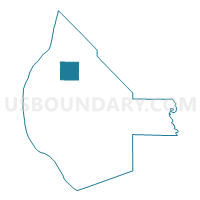
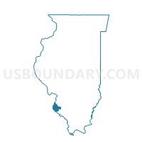
PRECINCT 14, Monroe County, Illinois
About
Outline

Summary
| Unique Area Identifier | 573609 |
| Name | PRECINCT 14 |
| County | Monroe County |
| State | Illinois |
| Area (square miles) | 8.87 |
| Land Area (square miles) | 8.81 |
| Water Area (square miles) | 0.05 |
| % of Land Area | 99.42 |
| % of Water Area | 0.58 |
| Latitude of the Internal Point | 38.37748080 |
| Longtitude of the Internal Point | -90.22703950 |
Maps

Graphs
Select a template below for downloading or customizing gragh for PRECINCT 14, Monroe County, Illinois


Neighbors
Neighoring Voting District (by Name) Neighboring Voting District on the Map
- PRECINCT 11, Monroe County, IL
- PRECINCT 15, Monroe County, IL
- PRECINCT 21, Monroe County, IL
- PRECINCT 22, Monroe County, IL
Top 10 Neighboring County Subdivision (by Population) Neighboring County Subdivision on the Map
- Precinct 14, Monroe County, IL (984)
- Precinct 21, Monroe County, IL (922)
- Precinct 11, Monroe County, IL (774)
- Precinct 22, Monroe County, IL (666)
- Precinct 15, Monroe County, IL (622)
Top 10 Neighboring Unified School District (by Population) Neighboring Unified School District on the Map
- Waterloo Community Unit School District 5, IL (17,917)
- Columbia Community Unit School District 4, IL (12,302)
- Valmeyer Community Unit School District 3, IL (2,549)